Surf Forecast Read and understand
- Introduction
- What is a surf forecast?
- Brief history of the Surf Forecast
- How are waves created?
- About the formation of waves
- Read surf forecast - These providers are available
- How do I read a surf forecast?
- The surf
- Five star surf - The rating of the waves
- The main fertilizer
- Secondary swell
- Wave period in seconds
- Waves with a low period
- Waves with a long period
- The periods of the waves
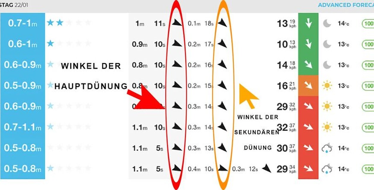
- The angle of the swell
- Swell direction
- Wind factor in the surf forecast
- Tide
- Influence of sunset and sunrise
- Extra feature in the Surf Forecast
- Read Surf Forecast conclusion

Jana is responsible for the website and blog at A-Frame. As a digital nomad and surf lover, she can work from anywhere in the world. She has currently opted for the Allgäu and El Palmar. For the Allgäu because of the love and for El Palmar because of the waves.
Introduction
When you are a guest at our surf camp, you don't have to worry about the surf forecast. We will always take you to the surf spot with the best conditions for your surf level. In the surf theory lessons, we will of course still be happy to explain to you how to read a surf forecast. For those who want to know now, we explain it step by step in this article.
What is a surf forecast?
The following points are included in a surf forecast and are explained in this article:
(Click on the corresponding parameter, you jump directly to the text)
Surf
Rating
Main swellSecondary swell
Wave period
Swell angle
Wind
Tide (tides)
Sunrise & Sunset
Extra features such as subsoil, wave type etc.
Brief history of the Surf Forecast
It wasn't that long ago that there were no apps or internet and you had to read the wave forecasts in the newspaper. Relatively complicated tables and satellite images were published on a daily basis and surfers could use this information to roughly imagine what the waves would be like in the near future.
At that time, weather and waves were only of interest to fishermen or sailors. Surfing was not as fashionable as it is today and there was no lobby for surfers.
This has changed over the last few years. The popularity of the sport has grown and with it the surfing business. You can now find many providers with detailed forecasts on the internet. Some of these are so accurate that professional surfers travel for days to get to a certain spot and surf high-quality waves or extremely large waves. Hobby surfers also sometimes travel "according to the forecast" and book a flight to the Atlantic at short notice to surf a good swell on a long weekend.
But even a forecast is ultimately nothing more than a "weather forecast" and can sometimes not quite turn out as predicted. You probably know this from the weather forecast at home or on vacation. Nevertheless, a surf forecast is largely reliable and a very important component among surfers.
How are waves created?
To make it easier to understand a surf forecast, it's good to understand something about wave formation. The topic of wave formation is very complex, so we'll keep it short and simple:
About the formation of waves
From low pressure area to surfable wave
Waves are created by wind or storms in a low pressure area out at sea. Chaos reigns in this strong storm. Waves of different sizes, small, strong and weak, are created. The waves travel out of the area where they originate and head for the surf spot. On the way, these waves organize themselves into sets (wave groups with waves of more or less the same size). At some point, these wave groups hit the coast and break over sandbanks, reefs or stone slabs as a surfable wave.
It is therefore not the water itself, but the energy that moves from the storm to the beach. This energy is passed on from wave to wave. This happens with the so-called "orbital motion". This phenomenon is explained very well on the Wikipedia page.
What we need for surfing
This sounds totally scientific, but it's not difficult: the water only starts to move when the wave actually breaks and throws itself forward. The closer the low pressure area is to the coast, the less time and space the waves have to organize themselves. In addition, coastal lows often bring unfavorable winds with them.
What we want for surfing are strong, large, long-lasting storms - far away from our surf spot. Many beginner surfers believe that strong local winds are necessary to get good waves. But that's not true, because strong winds directly on the beach tend to destroy the waves instead of making them surfable.
So, now you know a bit about how waves are created. Now you can start reading the surf forecast.
What is a "swell" anyway?
You may have heard it before: surfers often talk about good or bad swell. This can sometimes be confusing for beginners. What is this swell? Swell loosely translated means "swell wave". This is the wave that has traveled out of the wind area and is heading towards the beach. A distinction is made between windswell (rather poor conditions) and groundswell (which usually brings good quality conditions). But more on that later.
Read surf forecast - These providers are available
To read a surf forecast, you first need to have one in front of you. There are numerous providers for a good wave forecast. The best-known sites are http://www.surf-forecast.com/ and https://www.surfline.com. The advantage of Magicseaweed is the app that you can download onto your smartphone. So you always have your surf forecast with you. Magicseaweed.com also works together with the legendary Stormrider Surf Guide. This provides good descriptions of the surf spots as well as background information on the various surfing areas. There are also interesting articles about surf science and current events in the world of surfing. So if you want, you can spend hours on this site and get informed.
Many surfers also use Windguru to get even more precise information on the wind conditions.
How do I read a surf forecast?
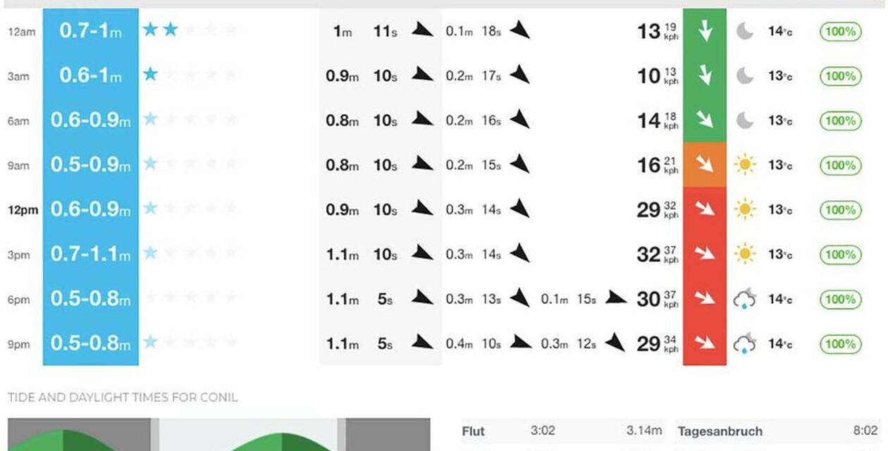
We will now show you how to read a surf forecast using the forecast from Surfline (formerly Magicseaweed)
.
The surf
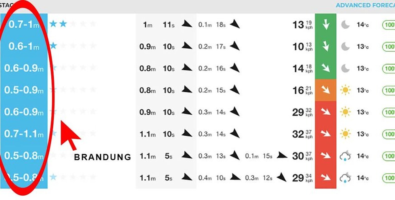
On the far left, next to the time, you can see the height of the surf. This tells you approximately how big the waves will be when they reach the beach. However, this should only be an indication. You should pay more attention to the swell itself.
Five star surf - The rating of the waves
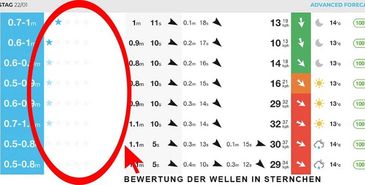
The stars should show you how well the individual parameters fit together on that day. So the better the wave height, wind direction, period and swell direction harmonize with each other, the more stars.
The main fertilizer
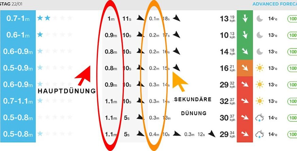
The main swell is the height of the swell on the open sea. It is predicted using satellite images or buoys equipped with sensors that move up and down with the waves. A group of waves heading for the beach sometimes travels thousands of kilometers. The buoy data is used to calculate how big the waves will be when they arrive at the spot.
Secondary swell
When a secondary swell is on its way, it means that a second low-pressure area has formed somewhere at sea, which is also sending waves to our spot. If this is the case, the two swells may interfere with each other and not arrive at the beach as cleanly. This can have a negative impact on the quality of the waves. In very rare cases, three swells can also be on the move. Then it gets really messy.
Wave period in seconds
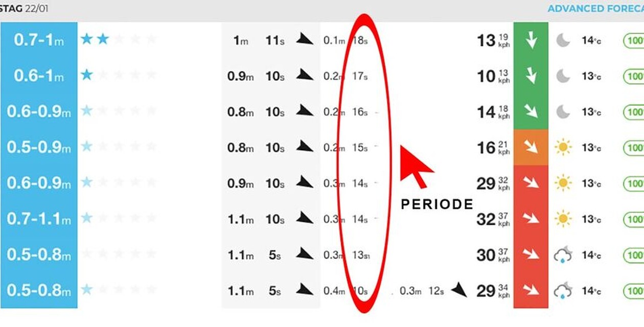
The numbers between the main swell and the secondary swell predict the wave period in seconds. This period is a very crucial component in surf forecast reading. The period is given in seconds because it is the length of the swell wave, measured in seconds. This is predicted using satellite imagery of the storm and measured using the same buoys that measure wave height. (Remember?) The following seconds are determined: from the highest point of one wave to the highest point of the next wave. Then you know the period of the wave.
This period is so important because you can see how orderly and clean a swell will arrive. In short: the longer the period, the more orderly the waves come in and the more power they have.
For all those who want to know more, our surf instructor Alex has worked out the difference between short and long periods. Have fun with Alex's surf theory ;-)
Waves with a low period
A wave that hits the beach with a low period is flabby and rather powerless and will not produce a good swell. The waves are wildly mixed up and difficult to recognize.
A low period is often also an indicator that the low pressure area is relatively close to the coast, as waves with a low period cannot travel for long due to their lack of power.
Due to the lack of distance to the wild storm at sea, it is often quite windy and small-period swells sometimes bring onshore wind conditions. This is why waves with a period of less than 10 seconds are referred to as windswells.
Waves with a long period
The wave period is also responsible for the waves being able to organize themselves. In the chaos of a storm, many different waves with different wavelengths are created. Waves with a long period travel faster than waves with a short period, and waves with a short period have very little power and die off on their way to the coast. They often do not reach our beach at all, unless the storm is close to the coast. This means that large-period waves travel faster out of the low-pressure area and can travel longer, while small-period waves arrive at the surf spot much later or not at all.
The periods of the waves
Order into chaos
So the big period ensures that the chaos is ordered and we get our nice clean lines for surfing. This phenomenon is well explained by the author of the book Surf Science, Tony Butt, who wrote a very good article on this subject for the forecast site Magicseaweed.com.
Waves with a high period are also much more powerful.
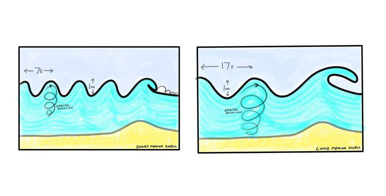
Imagine a wave with a height of one meter and seven seconds. And now imagine a wave with a height of one meter and a wavelength of 17 seconds. The energy contained in the second wave is much greater. This means that if a 17-second wave breaks over a sandbank with a wave height of one meter, the wave will be much higher and more powerful than the seven-second wave with the same wave height. There is also more volume in the wave. This means that more water is thrown forward when the wave breaks. As you can see, a one-meter wave is not just a one-meter wave. The wavelength in seconds has a huge influence on the breaking wave and the swell.
The angle of the swell
This parameter tells you which direction the swell is coming from. Depending on how the surf spot is aligned, this direction influences the quality and size of the wave. Here is an example from our home beach in El Palmar:
Swell direction
Swell from the west
At Playa El Palmar, we enjoy so-called west swells. This is because the beach here tends to face west. So when the waves come from the west, they hit us almost directly. The sandbanks can handle these swells well and produce good quality waves.
Swell from the north
If a swell has too much of a northerly component, two things can happen: Either the swell arrives much smaller than expected, as Portugal blocks the swell. Or the waves don't break as well because the angle of the swell is not suitable for the sandbanks here.
We are lucky here in the area to be able to switch to the south coast when the waves in El Palmar get too big. But even on this coast, you have to expect big surf when the west swell is big, as the angle is more favorable than with northwest swells, for example.
Swell from the south-west
In very rare cases, the swell comes from the south-west. Unfortunately, these are often wind swells that bring storms with them and do not produce really good waves. In and of itself, this direction would be good because there are many south-facing surf spots in our area
Wind factor in the surf forecast
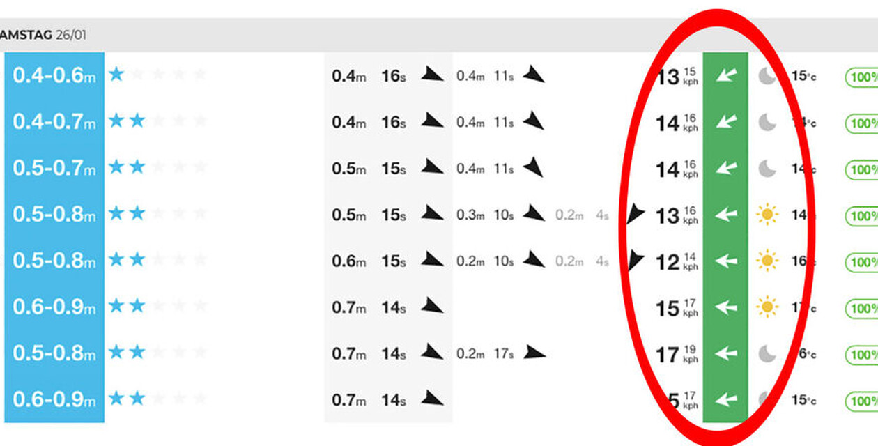
In the article about the right surf spot check, we already explained that the wind is very important for the quality of the waves. You can also see this in a surf forecast and adjust your surf session accordingly. Predicting the wind on the hour is not particularly easy. It usually makes sense to only check the wind for the next day and not to look too far into the future, as the forecasts are relatively inaccurate.
Tide
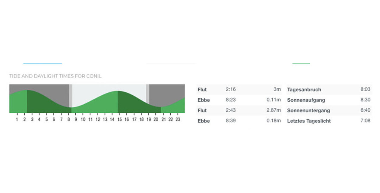
The last factor in reading the surf forecast is the state of the tide. Every surf spot has a certain tide level at which the waves break particularly well. The tidal range changes every day and the high tide (highest water level or rising tide) and low tide (lowest water level or falling tide) shift backwards by around an hour every day. To find out about this, it is worth checking the tide curve. This allows you to catch the optimum tide level for your surf session.
Influence of sunset and sunrise
What is your favorite time to go surfing? Sometimes you can't choose, but you have to go surfing when the conditions are best. However, you shouldn't surf at night because it's no fun and can be dangerous. So when surfing, pay attention to when the sun goes down. Especially during a sunset surf session, it is advisable to keep an eye on the clock.
Otherwise, you may be able to catch the first waves early in the morning with a view of the sunrise and the tide. There are usually not so many surfers in the water at sunrise. What's more, what better way to start the day than with surfing?
Extra feature in the Surf Forecast
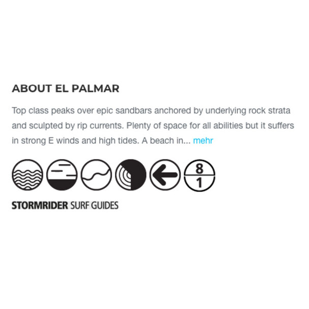
On many surf forecast sites, you can also see what the optimal conditions are for the respective spot. Magicseaweed.com, for example, uses simple symbols to indicate:
Which tide is the best?
What type of wave (beach break, point break, reef break)
The bottom
The ideal swell direction that works for this spot
The preferred wind direction for this surf spot
What size range the swell needs to be
Read Surf Forecast conclusion
You see, being able to read a surf forecast is very helpful for planning surf sessions and getting the most out of a surf vacation. However, the information from a surf forecast only becomes really effective with so-called "local knowledge". To do this, you often have to follow the forecasts for years, check different spots with different forecasts, correctly assess swell directions and be able to interpret local winds.
In other words, the more time you spend in an area, the better you learn to categorize all these numbers perfectly. Every beach has its own peculiarities and you only find them out over time. If you are a guest with us, always ask our surf instructor team for tips. Some of them have been living here in El Palmar for years and can certainly help you further.
